Boundary County Maps
These are maps of what is now known as Boundary County
They have been cropped from much larger maps of the Idaho or even the northwest.
- Click on the thumbnail image of the map on the right to enlarge for viewing
They have been cropped from much larger maps of the Idaho or even the northwest.
- Click on the thumbnail image of the map on the right to enlarge for viewing
- Your mouse wheel will zoom the map or use the controls under the enlarged map.
1875 Petermann's Vereinigte Staaten Von Nord-Amerika
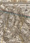
This map includes: Chelemta Depot & Sinyakwatee Depot
Full Title: Vereinigte Staaten Von Nord-Amerika In 6 Blattern, Bl. 1. Petermann. Bearbeitet v. H. Habenicht. Gest v. Metzeroth, Eberhardt, Kramer. Gotha: Justus Perthes 1872.
Author: Stieler, Adolf
Date: 1875
Source: David Rumsey Historical Map Collection
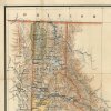
1883 Cram's Unrivaled Family Atlas of the World. by Geo. F. Cram

Full Title: Cram's Unrivaled Family Atlas of the World. Copyright 1883 by Geo. F. Cram. Chi. Ill. A.C. Shewey & Co., 264 Wabash Avenue, Chicago, Rushville, Ind.
Author: Cram, George Franklin
Date: 1883
Source: David Rumsey Historical Map Collection
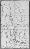
1888 Territory of Idaho General Land Office

This map includes: The town of Fry
Name on Item: compiled from the official records of the General Land Office and other offices, under supervision of Geo. U. Mayo ; compiled and drawn by Robert H. Morton.
Date: 1888
Source: Norman B. Leventhal Map Center Collection
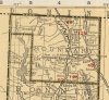
1891 Amerine's Sectional map of the Northwest
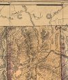
This map includes: Bonner Ferry, Eatonville, Moyea River, Lion Head Peak, Trout Creek, Stampede Lakes, Browns Creek
Title: Sectional map of Washington, Oregon, Idaho, and western Montana
Author: Amerine, C.H.
Date: 1891
Source: David Rumsey Historical Map Collection
1891 Rand McNally and Amerine's Map of Washington
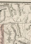
This map includes: Fry P.O. or Bonner Ferry, Mooyie River, Lion Head Peak, Stampede Lakes and the customs house at Ockanook
Title: Sectional Map Of Washington
Author: Amerine, C.H.
Date: 1891
Publisher: Rand McNally & Co.
Source: David Rumsey Historical Map Collection
1892 Bonners Ferry & Kootenai Country
This is a mining map published in the Kootenai Herald it includes the entire Kootenay Valley up into BC with the towns of Rykerts, BC, Bonners Ferry and the Halfway House on the wagon road south to Kootenai. It appears to show the WIld Horse Trail as well.
Title: Bonners Ferry and it's realitive position to the Kootenai Country
Author: I
Date: 1892
Source: The Kootenai Herald, 27 May 1892. Chronicling America: Historic American Newspapers-LOC
1899 United States Land Office
This map includes: This is a beautiful map with the towns of Eaton, Ockanook, Lucas and Moravia and shows Trout Creek in Naples.
Title: State of Idaho
Author: General Land Office
Date: 1899
Highly detailed wall map of Idaho, published by the General Land Office, under the supervision of Harry King.
1924 Rand McNally
This map includes: This is the best map to see majority of the communties of Boundary County. Including short lived train stop post offices, like Harper, Shultis, Kenney, Colony, Ritz, & Beardsmore on the KVR Rwy. Addie, Sinclair, Snyder, Meadow Creek, Eileen, Schnoors, Deep Creek and Shiloh in the SI Rwy. And Katka on the Great Northern.
Author: Rand McNally and Company
Date: 1924
Source: David Rumsey Historical Map Collection
:: Created August 2019 ::