Towns, Communities and Former Settlements
Some of the historical communities are: Addie, Beardsmore, Boulder City, Chelemeta, Colony, Copeland, Crossport, Curley Creek, Deep Creek, Deer Park, Eatonville, Eileen, Fry, Good Grief, Harper, Katka, Kenney, Klockman, Leonia, Lucas, McArthur, Meadow Creek, Moravia, OckonooK, Ritz, Reed, Rock Spur, Round Prairie, Schnoors, Shiloh, Shultis, Sinclair, Smith Creek, Snyder, and Swede Island.
Communities showing zip codes are the only "towns" currently in Boundary County. We are starting to add pages about the communities, especially those areas where no town exists today. When completed you will be able to click on these underlined names and find further information, and we hope, even photos.
Addie
Vacant old school still remains; post office from 1908 to 19542
Allens Spur
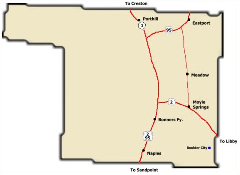
Bonners Ferry - 83805
Bonners Ferry from "History of Boundary County" 1987
and Bonners Ferry
Cort Conley in Idaho for the Curious writes (p. 668f): The old Indian-Wild Horse Trail from Seneacquoteen came north through this area (Bonners Ferry). When gold was discovered on Wild Horse Creek, British Columbia, in 1863, thousands of prospectors, conscripted by the fever, came up the trail via Walla Walla to cross the river at this point. Not one to let an opportunity drift past, [Edwin] Bonner obtained an exclusive five-year franchise from the Territorial Legislature for this seven-mile stretch of river. His toll rates were $1.50 for loaded pack animals and .50 for a person on foot. . . . After the mining boom subsided, the settlement of Bonners Ferry looked like it be stranded out of place and time. Richard [Frey] leased the ferry from Bonner in 1875 . . .
Boulder City
Burns
- In 1906 Burns Mill was located one half mile south of the Deep Creek bridge on the Moravia Road
Copeland
Still a thriving community, Copeland had a post office from 1900 to 19722
Crossport
Curley Creek
Deer Park
Eastport - 83826
Eastport is located on the northern border; established as a post office in 1906 2
Eatonville
Eatonville formally located on the eastern border of downtown Bonners Ferry is now part of the city.
Eileen
Eileen had a post office 1912 -1914
Fry (renamed Bonners Ferry)
Fry was the post office 1887 -1892
Leonia
"Ghost town" (several buildings and a cemetery); established as a post office named Leonai in 1892; named changed to Lenia in 1901 & to Leonia in 19232
Good Grief
Katka
Kenney
Kenney had a post office 1914 -1915
The Kenney school house and Kenny Post Office were located at the bottom of the today’s Turner Hill Road.
Klockman
Klockman had a post office 1916 -1930
Lucas
Lucas had a post office 1892 -1898
McArthur
Though once a thriving village, McArthur didn't last long. It had grown up quickly around William McArthur's homestead and lumber mill at the turn of the last century. Before the disastrous fire of 1922, there sat along the north side of the Great Northern Railway, a post office, a 2-story I.O.O.F Northern Lodge #81 building with a dance hall, a grocery store, a schoolhouse, and 17 saloons! All that remains now of the town is the small Odd Fellows cemetery nestled in the shade of the woods.
Meadow Creek
Old foundations still visible. Lots of lavender lilacs in spring. Post office 1910 -19432
Moravia
The former community of Moravia lies approximately 1 mile west of the Mirror Lake Golf Course. All that remains of the town are the cemetery, the school house (now a residence), and a motel (also now a residence). post office 1903 - 1917; 1918 - 19432
Moyie Springs - 83845
established as post office in 1926
Naples - 83847
Naples is at southern end of county. "Received its name from Italians working as construction crews for the Great Northern Railroad in the winter of 1892."1
OckonooK
Now called Porthill
Porthill - 83853
on northern border; established as a post office named OckonooK in 18932
It was in December 1893 that “Ockonook” became the official name of the new post office with ex-customs official; J. I. Barnes was its postmaster. A more correct spelling of Ockonook is Ahquonook, which means rocky and grassy hillside. Editor Taylor was appalled that they had decided on such a “heathen savage” name. On January 1, 1897, the site was renamed Port Hill, after customs inspector C. P. “Chippy” Hill. He had acquired most of the town site through a mineral claim. In 1916 Port Hill was the second largest community with a monthly newspaper published by S. T. Jordan. David McLaughlin was the official weather recorder.
Pine Island
By H. L. Talkington - 1922' As one approaches Bonner's Ferry, he will see on the north. Pine Island, a pine clad promontory, where Father De Smet met the Kootenai Indians in 1844, and again two years later. A short distance from here is a queer old Catholic Church established in very early days. In this town was established one of the first large saw mills in the state in 1903. This mill cuts 120,000 feet in eight hours, and 50,000,000 feet of lumber in a year.
Reed
Reed had a post office 1909 -1910
Ritz
Rock Spur - a spur of the Kootenai Valley RR near Copeland, renamed "Delbohm's Spur about 1910 (according to "My Kootenai" stories published in the Bonners Ferry Herald in 1976) (A 1927 map shows Rock Spur east of Crossport but many maps have serious errors)
Round Prairie
Schnoors
Shiloh
Sinclair
Sinclair had a post office 1914 -1933
Smith Creek
Snyder
Snyder had a post office 1908 -1913
Threemile Corner
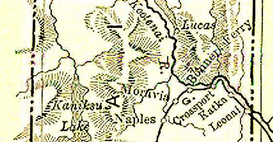
North Kootenai County in 1895, before Bonner County (1907) and Boundary County (1915) were formed
1Cort Conley. Idaho for the Curious/A Guide. Backeddy Books, Cambridge, Idaho. 1982
2Mark Metkin's Idaho post offices website
:: Latest Update April 2024 ::